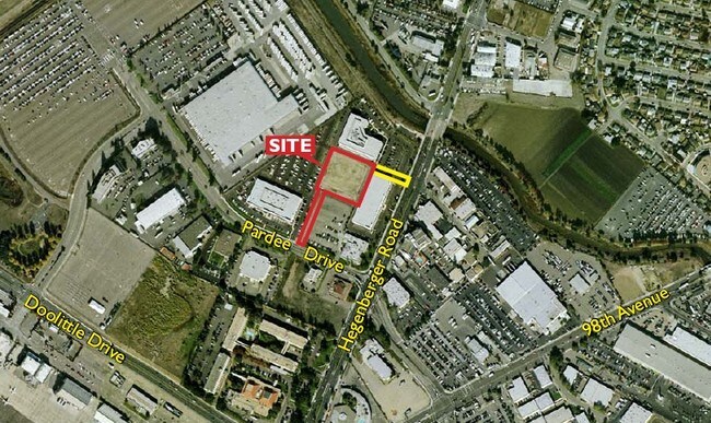
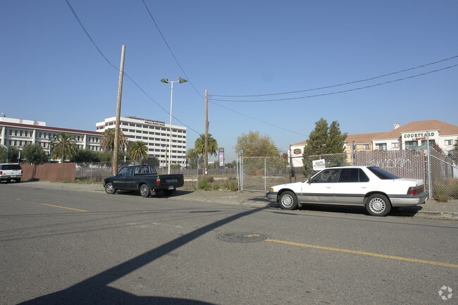
Property Record
195 Hegenberger Rd, Oakland, CA 94621


NEARBY LISTINGS FOR SALE OR LEASE
-
-
-
No Photo
-
-
-
-
-
View all Oakland listings for sale on LoopNet.com
Property Detail
195 Hegenberger Rd
042-4420-014-00
Parcel Map 8390
Hotel
LOT: 00002 BLK: PM: 0278 PAGE: 0055
X
Alameda
06001C0252H
California
2024
1.95 AC
2025
Oakland-South/Airport
409000
East Bay/Oakland
95,670 SF
Oakland-Hayward-Berkeley, CA
DEMOGRAPHICS near 195 Hegenberger Rd
1 Mile
3 Mile
5 Mile
2024 Total Population
5,662
156,085
372,442
2029 Population
5,487
150,593
359,367
Pop Growth 2024-2029
(3.09%)
(3.52%)
(3.51%)
Average Age
38
39
40
2024 Total Households
1,310
48,167
125,604
HH Growth 2024-2029
(3.36%)
(3.72%)
(3.69%)
Median Household Inc
$67,631
$75,136
$83,406
Avg Household Size
3.70
3.00
2.80
2024 Avg HH Vehicles
2.00
2.00
2.00
Median Home Value
$474,435
$732,646
$783,697
Median Year Built
1951
1955
1955
Nearby Places
Map Layers
Map Styles
 Street
 Aerial
- Restaurants
- Banks
- Shops
- Fitness
- Groceries
PUBLIC TRANSPORTATION
COMMUTER RAIL
DRIVE
WALK
Distance
11 min
7.1 mi
DRIVE
WALK
Distance
13 min
8.2 mi
AIRPORT
Metro Oakland International
DRIVE
WALK
Distance
Metro Oakland International
5 min
2.3 mi
San Francisco International
DRIVE
WALK
Distance
San Francisco International
39 min
29.9 mi
Norman Y Mineta San Jose International
DRIVE
WALK
Distance
Norman Y Mineta San Jose International
44 min
34.5 mi
Freight Ports
Port of Oakland
DRIVE
WALK
Distance
Port of Oakland
12 min
7.6 mi
Nearby Properties
Address
Land Use
TOTAL SIZE
Lot Size
Zoning
Address
Land Use
TOTAL SIZE
Lot Size
Zoning
219,200 SF
5.49 AC
Address
Land Use
TOTAL SIZE
Lot Size
Zoning
285,595 SF
53.21 AC
Address
Land Use
TOTAL SIZE
Lot Size
Zoning
534,208 SF
23.18 AC
Address
Land Use
TOTAL SIZE
Lot Size
Zoning
165,923 SF
14.99 AC
Address
Land Use
TOTAL SIZE
Lot Size
Zoning
597,179 SF
19.16 AC
Address
Land Use
TOTAL SIZE
Lot Size
Zoning
726,931 SF
37.03 AC
Address
Land Use
TOTAL SIZE
Lot Size
Zoning
713,010 SF
19.96 AC
Address
Land Use
TOTAL SIZE
Lot Size
Zoning
128,650 SF
6.38 AC
Address
Land Use
TOTAL SIZE
Lot Size
Zoning
1.64 AC
Address
Land Use
TOTAL SIZE
Lot Size
Zoning
525,864 SF
16.53 AC
Address
Land Use
TOTAL SIZE
Lot Size
Zoning
180,959 SF
9.38 AC
Address
Land Use
TOTAL SIZE
Lot Size
Zoning
289,747 SF
11.31 AC
Address
Land Use
TOTAL SIZE
Lot Size
Zoning
374,725 SF
18.63 AC
Address
Land Use
TOTAL SIZE
Lot Size
Zoning
203,925 SF
8.54 AC
Address
Land Use
TOTAL SIZE
Lot Size
Zoning
336,680 SF
9.93 AC
M40
Address
Land Use
TOTAL SIZE
Lot Size
Zoning
323,080 SF
12.50 AC
I2
Address
Land Use
TOTAL SIZE
Lot Size
Zoning
99,039 SF
1.04 AC
Address
Land Use
TOTAL SIZE
Lot Size
Zoning
235,760 SF
9.52 AC
Address
Land Use
TOTAL SIZE
Lot Size
Zoning
292,698 SF
12.92 AC
Address
Land Use
TOTAL SIZE
Lot Size
Zoning
284,255 SF
5.07 AC
Address
Land Use
TOTAL SIZE
Lot Size
Zoning
214,062 SF
16.20 AC
Address
Land Use
TOTAL SIZE
Lot Size
Zoning
200,238 SF
9.28 AC
Address
Land Use
TOTAL SIZE
Lot Size
Zoning
24.51 AC
Address
Land Use
TOTAL SIZE
Lot Size
Zoning
132,018 SF
1.11 AC
Address
Land Use
TOTAL SIZE
Lot Size
Zoning
133,678 SF
4.33 AC
Address
Land Use
TOTAL SIZE
Lot Size
Zoning
138,196 SF
8.47 AC
Address
Land Use
TOTAL SIZE
Lot Size
Zoning
168,104 SF
13.73 AC
Address
Land Use
TOTAL SIZE
Lot Size
Zoning
231,756 SF
9.15 AC
Address
Land Use
TOTAL SIZE
Lot Size
Zoning
136,618 SF
6.34 AC
Address
Land Use
TOTAL SIZE
Lot Size
Zoning
155,000 SF
8.41 AC
The World's #1 Commercial Real Estate Marketplace
Connect with us
© 2025 CoStar Group
The information above has been obtained from sources believed reliable. While we do not doubt its accuracy we have not verified it and make no guarantee, warranty or representation about it. It is your responsibility to independently confirm its accuracy and completeness. Any projections, opinions, assumptions, or estimates used are for example only and do not represent the current or future performance of the property. The value of this transaction to you depends on tax and other factors which should be evaluated by your tax, financial, and legal advisors. You and your advisors should conduct a careful, independent investigation of the property to determine to your satisfaction the suitability of the property for your needs.